José Maria de Jesus Alviso Adobe and Rancho Milpitas, (two)

Milpitas People and Places

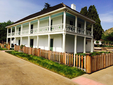
Historic Places José Maria de Jesus Alviso Adobe and Rancho Milpitas. The recently restored Alviso Adobe residence as it appeared in 2013. (Photo courtesy of Joseph Ehardt, Milpitas Historical Society)The recently restored Alviso Adobe residence as it appeared in 2013. (Photo courtesy of Joseph Ehardt, Milpitas Historical Society)

by Joseph Ehardt, Docent, Milpitas Historical Society

Table of Contents—
Page One—click here

Page Two

  • Some aspects of early life in Milpitas Village
  • The fragmentation of Rancho Milpitas
  • The Cuciz era of Rancho Milpitas begins
  • The final transformation of Rancho Milpitas and its Adobe into a public park

Some aspects of early life in Milpitas Village

Only a little more than a decade later, a whirlwind of unforeseen events blew in. In the mid-1800s, new fortune-seeking settlers poured in from the eastern U.S. and elsewhere because of the California Gold Rush and its prospects of statehood. Upon leaving the gold fields (after having struck it rich, though more commonly not), or even bypassing them entirely, new Milpitas townfolk settled on the western edge of the Rancho along what was referred to as The Mission Road (from El Pueblo San José Guadalupe to Mission San José); others put down roots in the more open eastern foothill rangelands. They typically grew private gardens of squash, corn, beans and other edible crops along or near the banks of the nearby Penitencia and Coyote Creeks. Penitencia Creek was the western boundary of Rancho Milpitas; Coyote Creek was the western boundary of Rincon de los Esteros.

Briefly Milpitas township was known as Penitencia by its locals until the first postmaster objected that the name was too reminiscent of “penitentiary,” which is quite ironic because in this era Milpitas is the site of Elwood Correctional Facility. During the 1870s immigrant John O’Toole owned a 584-acre property in southern Milpitas with Elmwood trees lining the lane leading from the Mission Road (aka the Old Oakland Highway) to his residence; it was later purchased by Santa Clara County to be used initially as a almshouse (a home for the poor), but it gradually transitioned into housing for low-security inmates presaging its current use.
Like the townspeople, José Maria Alviso grew some table crops near to the Adobe, close to the Arroyo de los Coches that ran along the northern boundary of his land, but primarily he was a conventional Hispanic ranchero who raised cattle. It should be noted that during the Spanish and Mexican eras, the chief source of income for the owners of ranchos came from the sale (or desirable trade) of cattle hides and tallow, a practice described in detail in the 1840 book by Richard Henry Dana, Two Years Before the Mast. Thus, during the Mexican era, there existed a highly commercial and profitable shipping economy of exporting goods from Alta Californa and importing other goods from the Eastern United States.

As José’s family expanded to nine children, additional living space was needed, so a second story was added to Alviso Adobe in the early 1850s, transforming his original single-story Spanish Adobe with 22-inch thick adobe walls into the Monterey Colonial style described previously.

The fragmentation of Rancho Milpitas

Juana Francisca Galindo Alviso (1806-1885), widow of José, in 1858 married her manager of Milpitas Rancho, José Galacion Urridias, not long after he was hired, as it turns out, who thereafter acted as guardian of the three youngest Alviso children.

Sadly, the pressure of unstoppable and life-altering changes resulted in the beginning of the slow dissolution of Rancho Milpitas. A major reason was that legal expenses incurred to defend the Alviso family title to the property necessitated an occasional need for hard-to-come-by cash, resulting in acreage being sold off piece by piece as legal action seemed to never end. Another reason for decreasing the amount of the Rancho acreage was providing inheritances of property to José’s descendants.

Sometime about 1871, with the Rancho’s title finally secured, the now twice-widowed Juana gave her second oldest daughter, Maria Carmen Alviso (1829-1890), then wife of Jose Antonio Narvaez (1824-1901), a 78.79-acre parcel of land that included the current Alviso Adobe. Juana also gave her youngest daughter, Maria Guadalupe de los Angeles Alviso (1844-1920), wife of Bartolome Sepulveda (1839-1926), a 35-acre section of land (south of Maria Carmen’s section) on which there was another (probably smaller) adobe.

When Juana died in 1882, the remaining land that had not been sold off previously was legally partitioned among the surviving nine descendants. That land is depicted in a plat map dated 1890 and is referred to as “The Urridias Partition” running west of the Alviso Adobe along Calaveras Road and extending partly toward the Oakland Highway (our Main Street).

The Cuciz era of Rancho Milpitas begins

The Cuciz family bought the northeastern section of the original Rancho from the Gleason family in 1922. This property had been inherited earlier by Catherine Christina Narvaez (1857-1948) from her mother, Maria Carmen Alviso Narvaez, who in turn had received it from her mother, Juana Francisca Galindo Alviso. Thus, Catherine Narvaez was the direct granddaughter of José Maria de Jesus Alviso and the wife of James A. Gleason (1857-1919), so the chain of title is clearly established and definitively identifies who sold the property to the Cuciz’s.

The Cuziz family gradually made many improvements to their farm and the house. They planted orchards of fruit trees, replaced the original exterior lean-to kitchen with an attached kitchen addition integrated within the house, remodeled and electrified the interior, erected a water tankhouse, built a carriage shed, a drying shed, and a barn partly constructed of timbers salvaged from three adobes that were town down, all of which is documented in the site’s Historic Landmark registration of 1997.

Even so, while making these changes, they respectfully retained as much of the historical legacy of the original property as practicable. In the early 1980s, the Cucizes sold most of the property to the nearby Calvary Assembly of God Church.

The final transformation of Rancho Milpitas and its Adobe into a public park

The City of Milpitas acquired the historic Adobe site, which includes 2.2 acres of land, from the Calvary Church in 1996, and this building is now an historic landmark in final stages of restoration (from an architectural point of view, more accurately the Adobe has been renovated, that is, refinished and repurposed for its new role as a multi-faceted museum).

The City of Milpitas has spent almost two decades strengthening the residence against earthquakes and slowly repaired it and the outbuildings to yield the current historic park. It showcases the original Mission black fig tree, two old sycamores (one dating back an estimated 165+ years), as well as replanted apricot trees to evoke the orchard that previously existed during the Cuciz period. Positioned under the giant sycamore is older-era farm equipment donated by the family of the now-deceased Mabel Mattos, former Milpitas historian and namesake of the newest Milpitas elementary school, not far from the Great Mall.

Happily, the renovated and adapted ground floor of the Alviso Adobe is nearly completed and will be opening as a museum providing docent-led tours for the public in general and by special arrangement for busloads of curious Milpitas students. In doing so, the Alviso Adobe will become alive again with people ambling through its historic spaces and teaching people about life spanning almost two centuries.

In Spring of 2013 the City had a dedication ceremony opening this public park located at Alviso Adobe Court cul-de-sac near Piedmont and Calaveras Roads. The grounds are securely gated at night to protect the historic buildings, but Alviso Park is opened for visitation in the morning and closed about dusk. In terms of facilities, it provides two bathrooms and eight picnic tables located around four grills for cooking hot food. Also, there is prominent signage providing historical information at many places of interest within the park.

(Page One—click here)